Forayz: Mushroom Foraging Map for the Pacific Northwest Burn perimeters, soil data, snowmelt, forest types, and habitat models for Washington, Oregon, and the wider Western US
Forayz combines a half-dozen government data feeds into one map you can plan a trip from: where it burned, where the soil is warm, where snow has just melted, what kind of forest you’re driving into, and whether the land is open to foraging.
Free with a registered account. Pro unlocks burn perimeters, habitat models, forest-type density layers, and offline downloads.
At a Glance
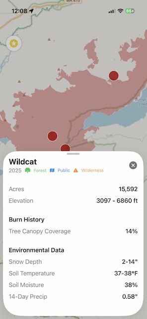
Burn perimeters
Wildfires across the Western US, filterable by year, with severity overlay for 2023–2025 fires.
Soil temp & moisture
Daily updates via satellite. Watch the 45-50°F threshold morels seem to prefer.
Snow & snowmelt
Current snowcover and recent snowmelt zones in spring.
14-day precipitation
Recent rainfall plus 30-year normals for regional context.
Forest types
Tree maps to help you find habitat by tree type including Douglas-fir, cottonwood, true fir, ponderosa pine, oak, and more.
Habitat models (Experimental)
Spring king fruiting windows and matsutake habitat zones, in season.
Public lands
PAD-US (US) and CPCAD (Canada). Federal, state, provincial, and local.
Roads & trails
USFS road network with road numbers, plus maintained trails.
Offline downloads
Save a region before you leave home. The map keeps working with no signal.
Try it free
Environmental layers are free with a registered account. No credit card.
Map Layer Catalog
Layers are grouped the way the in-app panel groups them. Free layers need a Forayz account; Pro layers require a membership.
Environmental Data
- Snow Coverage Free
- Recent Snowmelt Pro
- Soil Temperature Free
- Soil Moisture Free
- 14-Day Precipitation Free
- Precipitation Zones (30-yr normals) Free
- Ecoregions Free
Burns, Harvests & Disturbance
- Recent Burns (date-filterable) Pro
- Burn Severity (BAER / RAVG) Pro
- Historical Burns (25K+ perimeters, 2005–2023) Free
- Active Wildfires (NIFC, current season) Free
- Timber Harvests Pro
- Disturbed Forests (NASA OPERA, non-fire loss) Pro
Habitat Models
- Spring King Potential (Apr–Jul, by zone) Pro
- Matsutake Habitat (experimental, Jul–Dec) Pro
Forest Types (13 PNW Groups)
- Alder / Maple Pro
- Cottonwood Pro
- Douglas-fir Pro
- True Fir Pro
- Larch Pro
- Madrone Pro
- Oak Pro
- Lodgepole Pine Pro
- Ponderosa Pine Pro
- White Pine Pro
- Engelmann Spruce Pro
- Sitka Spruce Pro
- Tanoak Pro
Land Access & Reference
- Public Access Lands (US + Canada) Free
- Land Use Parcels (WA only) Free
- Forest Roads (USFS, numbered) Free
- Trails (USFS maintained) Free
- Events (classes, forays, meetups) Free
Free vs. Pro
One account works across web, iOS, and Android.
| Feature | Free | Pro |
|---|---|---|
| Base maps (street, terrain, satellite) | ✓ | ✓ |
| Soil temperature & moisture | ✓ | ✓ |
| 14-day precipitation & 30-year normals | ✓ | ✓ |
| Snow coverage | ✓ | ✓ |
| Ecoregions | ✓ | ✓ |
| Active wildfires | ✓ | ✓ |
| Historical burns (2005–2023) | ✓ | ✓ |
| Public lands (US + Canada) | ✓ | ✓ |
| Forest roads & trails | ✓ | ✓ |
| Events layer | ✓ | ✓ |
| Recent burns (date-filterable) | — | ✓ |
| Burn severity overlay | — | ✓ |
| Recent snowmelt zones | — | ✓ |
| Timber harvests | — | ✓ |
| Disturbed forests (NASA OPERA) | — | ✓ |
| Forest types (13 PNW groups, density) | — | ✓ |
| Spring king & matsutake habitat models | — | ✓ |
| Areas of interest (saved regions) | — | ✓ |
| Offline map downloads | — | ✓ |
Pricing & no auto-renewal
Forayz Pro is a one-year, non-renewing membership. $14.99 on the web, $19.99 in the App Store and Google Play (Apple and Google take a cut). When the year ends, you decide whether to renew.
How Foragers Use It Through Morel Season
| Window | What to check |
|---|---|
| March – AprilLandscape morels | Soil temperature in urban areas. When it crosses 50°F, woodchip beds in parks and neighborhoods start producing. |
| April – MayRiver-valley naturals | 14-day precipitation along cottonwood corridors. Use the Cottonwood forest-type layer to find candidate stands. |
| May – JuneMid-elevation burns | Recent Burns filtered to last year’s fires, soil temperature overlay on top. Check snow coverage to see which burns are accessible. |
| June – JulyHigh-elevation burns | Snowmelt zones and burn perimeters together. North-facing slopes hold out longer; watch for late-spring rain. |
Why burn maps matter
When wildfire kills conifer trees, mushrooms like morels can fruit heavily the following spring and sometimes for years after. First-year burns are often the most productive. The harder problem is knowing which burns to drive to and when conditions are right. Burn perimeters paired with soil temperature and snow coverage answer both. For more on burn strategy, see the guide to finding morels in Washington.
2026 burn data is live
Recent burns, severity overlay, soil temperature, and snowmelt — updated for the current season.
Three Platforms, One Account
- Web at salishmushrooms.com/forayz. No install. Works on desktop, tablet, and phone browsers.
- iOS on the App Store. Offline downloads, save tracks & waypoints
- Android on Google Play. Same as iOS
FAQ
What does Forayz cost?
Free with a registered account for environmental layers, tree species, public lands, historical burns prior to 2022. Pro is $14.99/year on the web, $19.99/year in the App Store and Google Play.
Where does Forayz work?
Western US. Some layers (active wildfires, burn perimeters, forest types) extend across the lower 48.
Can I use it offline?
Pro members can download a map region in the iOS or Android app and use it without cell service.
Does the Pro membership auto-renew?
No. It’s a one-year membership. When it ends, you choose whether to renew.
How is it different from other mushroom foraging apps?
Forayz focuses on the conditions that drive fruiting (soil temperature, recent rain, snowmelt, burn perimeters, forest type). The question it’s built to answer is when and where to go, not what someone else found last week.
Is it useful outside of morel season?
Yes. The matsutake habitat model covers fall. Forest-type and ecoregion layers help locate chanterelle, hedgehog, and bolete habitat. Soil moisture and 14-day precipitation matter year-round for any fruiting species.
From Salish Mushrooms
Forayz is built by Salish Mushrooms, a Seattle-based mushroom education company. We also run guided tours, in-person classes, and free online lessons. Forayz started as a tool we made for ourselves to answer the question every tour begins with: how did you know to come here?