Forayz: Mushroom Foraging Map for the Pacific Northwest Burn maps, soil data, and environmental layers to help you find mushrooms in Washington, Oregon, and beyond
Forayz is a mushroom foraging map built for the Pacific Northwest. It combines burn perimeters, real-time soil temperature, snow cover, precipitation data, and public land boundaries into one tool — so you can scout foraging spots from home instead of driving blind.
Whether you’re hunting burn morels in the Cascades, tracking chanterelle season on the coast, or scouting for spring kings, Forayz gives you the environmental data that actually matters for finding mushrooms.
What Makes Forayz Different
Forayz makes it easy to track conditions that matter to the mushroom AND the forager.
- Burn perimeters from recent wildfires across the western US, filterable by year — essential for morel hunting
- Real-time soil temperature so you know when the ground has warmed enough for morels to fruit
- 14-day precipitation to track recent rainfall and predict fruiting events
- Snow cover data to monitor snowmelt at higher elevations
- Ecoregion boundaries to find similar habitat types across the region
- Public land boundaries so you know where you can legally forage
- Timber harvest data showing recent logging activity — another trigger for mushroom fruiting
- Disturbed forests from satellite detection — timber harvest, blowdown, and disease areas where morels may fruit
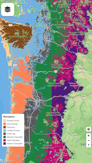
- Forest Types mapping ten distinct PNW forest habitats using LANDFIRE vegetation data — see exactly where cottonwood corridors, old-growth conifers, and high-elevation fir stands are located
The result is a map that helps you answer the real foraging question: where should I go this weekend, and is it worth the drive?
Try It Free
Environmental layers are free for all registered members. No credit card required — just create an account and start exploring.
Burn Morel Maps for Washington & Oregon
Burn morels are the most sought-after spring mushroom in the Pacific Northwest, and finding productive burn sites is the hardest part. Forayz maps every wildfire perimeter from recent years across Washington, Oregon, Idaho, Montana, and California — so you can scout burns without spending hours on InciWeb or NIFC databases. Layer with soil temperature, soil moisture, and recent precipitation to help time your trip around suitable conditions.
How foragers use burn data on Forayz
- Filter burns by year to focus on first-year fires (the most productive for morels)
- Check fire details including acreage, discovery date, and cause
- Layer soil temperature on top of burns to see which sites have warmed past the 50°F morel threshold
- Monitor snow cover at high-elevation burns where snowmelt timing determines the fruiting window
- Check public land status before driving — not all burns are on accessible land
Why burn maps matter for morel hunting
When wildfire kills conifer trees, the mycorrhizal fungi in the root systems produce a massive fruiting the following spring. First-year burns can produce thousands of morels. But you need to know where the fires were and when the soil conditions are right — that’s exactly what Forayz shows you.
For more on burn morel strategy, see our complete guide to finding morels in Washington.
Data Layers
Forayz includes both environmental layers (available to all members) and overlay layers (Pro members). Here’s what each layer does and why it matters for foraging.

Soil Temperature
Real-time soil temps across the region. Morel hunters watch for areas crossing 50°F — the threshold that triggers fruiting. Updated daily from NOAA data.
Free
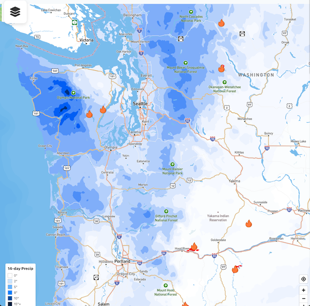
14-Day Precipitation
See where it rained in the past two weeks. Critical for fall mushrooms like chanterelles and for timing late-season burn morel flushes triggered by rain.
Free
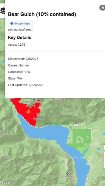
Past Burns
Wildfire perimeters across the western US, filterable by year. The primary tool for scouting burn morel sites in spring and early summer.
Pro
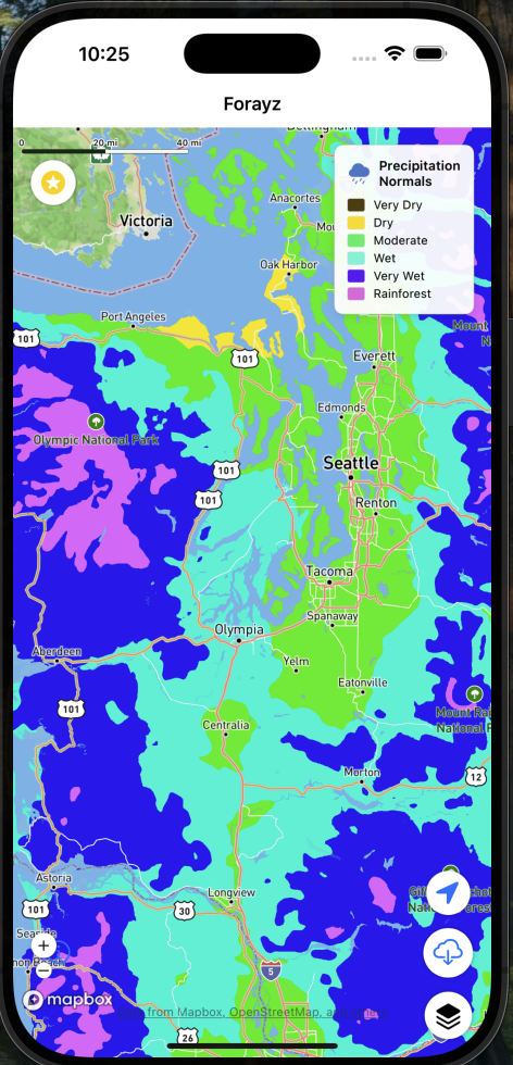
Precipitation Normals
30-year average rainfall data. Helps you identify habitat types — coastal rainforests vs. dry eastside forests — and find areas with the right moisture profile for your target species.
Free
Ecoregions
EPA Level III and IV ecoregion boundaries. If you find a productive spot in one ecoregion, use this layer to find geographically similar areas with matching habitat.
Free
Forest Types
Ten PNW forest habitats mapped from LANDFIRE EVT 2023 data — Coastal Rainforest, W. Cascades Conifer, High Cascades Fir, Ponderosa Pine, Lodgepole Pine, Rocky Mtn Douglas-fir, Rocky Mtn Spruce-Fir, Black Cottonwood, Garry Oak, and California Oak. Radio-select one at a time to highlight it on the map. Pair with burn perimeters to verify whether a fire burned through productive conifer habitat.
Pro
Disturbed Forests
Satellite-detected forest disturbance across the western US — timber harvest, blowdown, and disease. Built from NASA OPERA data, these areas highlight non-fire forest loss where morels may fruit. Complement to the burn perimeter layer for scouting productive ground beyond fire sites.
Pro
Additional layers include soil moisture, snow cover, timber harvests (recent logging — another morel trigger), and public land boundaries (national forest, BLM, state land).
Free vs. Pro
Forayz is free to use with a registered account. Environmental data layers are available to all members. Pro unlocks the overlay layers — burn maps, timber harvests, areas of interest — plus offline map downloads for use outside cell service.
| Feature | Free | Pro ($14.99/yr) |
|---|---|---|
| Base map (streets + satellite) | ✓ | ✓ |
| Soil temperature & moisture | ✓ | ✓ |
| 14-day precipitation | ✓ | ✓ |
| Snow cover | ✓ | ✓ |
| Ecoregions | ✓ | ✓ |
| Precipitation normals | ✓ | ✓ |
| Public lands | ✓ | ✓ |
| Forest Types (10 habitat layers) | — | ✓ |
| Past burn perimeters | — | ✓ |
| Timber harvests | — | ✓ |
| Disturbed forests | — | ✓ |
| Areas of interest | — | ✓ |
| Offline map downloads | — | ✓ |
Non-renewing annual membership
Forayz Pro is $14.99/year and does not auto-renew. No surprise charges. When your year is up, you choose whether to renew. Available through the iOS App Store, Google Play, or directly on the web.
Morel Season 2026: Using Forayz to Scout
Morel season in Washington and Oregon runs from March through July, progressing from low-elevation landscape morels to high-elevation burn sites. Here’s how to use Forayz at each stage:
- March–April (landscape morels): Check soil temperature in urban areas. When soil crosses 50°F in your city, start checking woodchip beds in parks and neighborhoods.
- April–May (river valleys): Use the precipitation layer to find areas with recent rain along rivers. Yellow morels fruit near cottonwoods in sandy, well-drained soil.
- May–June (mid-elevation burns): Turn on the burn perimeter layer filtered to last year’s fires. Layer soil temperature on top — south-facing slopes warm first. Check snow cover to see if high-elevation burns are accessible.
- June–July (high-elevation burns): Monitor snow retreat at higher elevations. As snow melts and soil warms, north-facing slopes become productive. Watch for late-spring rain events that trigger new flushes.
2026 Morel Maps Are Live
Burn perimeters, soil temperature, and snow cover — updated for the 2026 season. Scout your burn sites before you drive.
Available on iOS, Android & Web
Forayz works in your browser on any device — no download required. For offline use and mobile-optimized experience, native apps are available for iPhone and Android.
- Web app at salishmushrooms.com/forayz — works on desktop, tablet, and phone browsers
- iOS app on the App Store — optimized for iPhone with offline map downloads
- Android app on Google Play — full feature parity with iOS
Your account works across all platforms. Start scouting on your laptop, then take the same map offline on your phone when you head into the field.
Frequently Asked Questions
Is Forayz free?
Yes. Environmental data layers (soil temperature, precipitation, snow cover, ecoregions, public lands) are free for all registered members. Pro layers (burn maps, timber harvests, offline downloads) require a Pro-level purchase ($15 web/ $20 app stores).
Does Forayz work for morel hunting?
It was largely built for morel hunters. The burn perimeter layer shows recent wildfires where morels are likely to fruit the following spring. Layer soil temperature on top to know when conditions are right, and check snow cover at higher elevations to time your trip.
What area does Forayz cover?
Forayz covers the western US and Canada.
Can I use Forayz offline?
Pro members can download map regions for offline use — essential when foraging in areas without cell service. Download your target area before you leave home, and the map works fully offline in the field.
How is Forayz different from other mushroom apps?
Forayz is focused on the conditions that promote mushroom growth helping you choose where AND when to go.
Does the Pro membership auto-renew?
No. Forayz Pro is a non-renewing annual membership. You’ll never be charged automatically. When your year is up, you decide whether to renew.
From Salish Mushrooms
Forayz is built by Salish Mushrooms, a mushroom education company based in Seattle. We also offer guided mushroom tours, foraging classes, and free online lessons covering PNW species identification. Forayz grew out of the same question we hear on every tour: “How do you know where to go?”